
PHXLink
The city of Phoenix launched its own microtransit service in October 2026, with three service zones. A north zone in Deer Valley, a south zone in Laveen, and a west zone in Maryvale. The service is part of a three-year pilot program named Project EASE (Effective Access Solutions for Easing Congestion) and funded through FHWA Congestion Relief Grants.
Service Hours
All PHXLink zones operate between 6 am and 8 pm everyday.
North Zone
The PHXLink North Zone serves Deer Valley areas approximately north of Union Hills Dr, east of 51st Ave, south of Happy Valley Rd, and west of 16th St. Trips can also be made to and from the Deer Valley Park and Ride at Bell Rd and Interstate 17 to connect to new bidirectional, all-day I-17 RAPID service.
Existed since: 2026
Operator: Via Transportation
Service Area: 16 miles²
Service Bounds: Deer Valley - north of Union Hills Dr, east of 51st Ave, south of Happy Valley Rd, west of 16th St
Connecting Routes: 7 19 27 35 43 170 186 I17 GONB
History
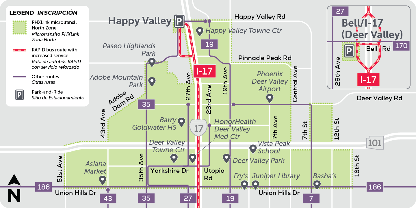
- October 26, 2026 - PHXLink North Zone introduced for Deer Valley, approximately bounding Union Hills Dr, 51st Ave, Happy Valley Rd, and 16th St, with service to and from Deer Valley Park and Ride
South Zone
The PHXLink South Zone serves the Laveen area approximately north of Olney Ave, east of 59th Ave, south of Broadway Rd, and west of Central Ave, excluding areas that are in county islands. Trips can also be made to and from the South Mountain Park Visitor Center and the 19th Ave Trailhead for South Mountain.
Existed since: 2026
Operator: Via Transportation
Service Area: 14 miles²
Service Bounds: Laveen - north of Olney Ave, east of 59th Ave, south of Broadway Rd, west of Central Ave
Connecting Routes: B 0 8 16 19 35 51 52 61 77 SMW
History
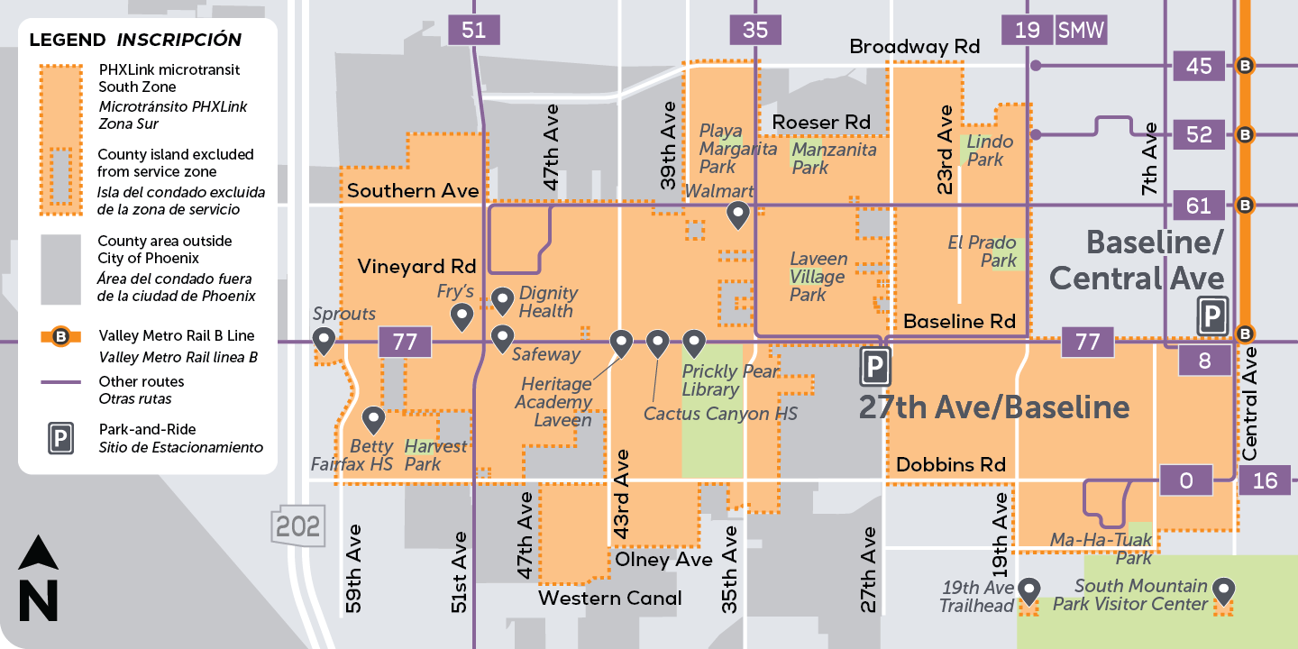
- October 26, 2026 - PHXLink South Zone introduced for Laveen, approximately bounding Olney Ave, 59th Ave, Broadway Rd, and Central Ave, with service to and from the South Mountain Park Visitor Center and 19th Ave Trailhead
West Zone
The PHXLink West Zone serves the Maryvale area approximately north of Van Buren St, east of the Agua Fria River, south of Bethany Home Rd, and west of 73rd Ave.
Existed since: 2026
Operator: Via Transportation
Service Area: 13 miles²
Service Bounds: Maryvale - north of Van Buren St, east of the Agua Fria River, south of Bethany Home Rd, west of 73rd Ave
Connecting Routes: 3 17 29 41 50 75 83 685 I10W MARY GONB WRDE
History
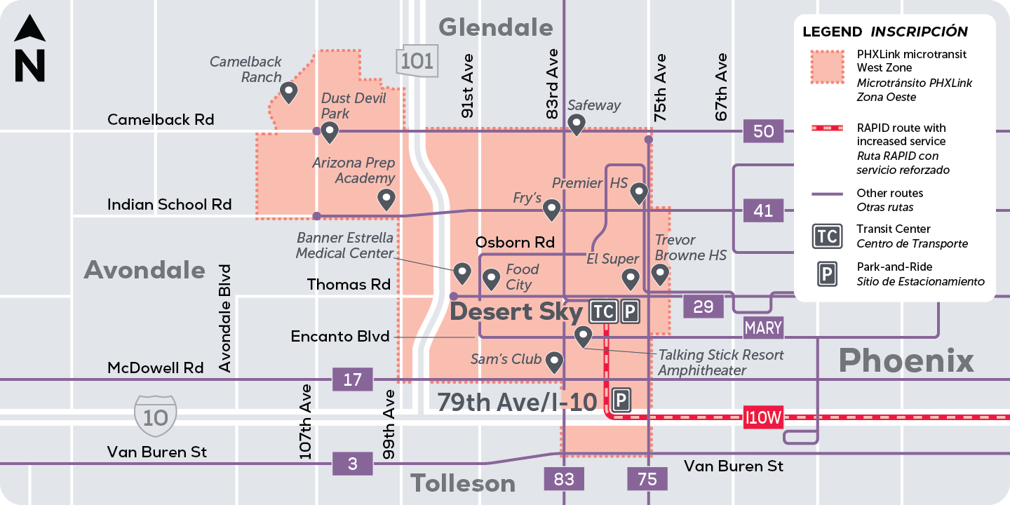
- October 26, 2026 - PHXLink West Zone introduced for Maryvale, approximately bounding Van Buren St, the Agua Fria River, Bethany Home Rd, and 73rd Ave
Page last updated: