
Deer Valley Express
Express route 590 traveled from the State Capitol, through Downtown Phoenix, up Central Ave, Bethany Home Rd, Interstate 17, and Bell Rd to the Bell Rd/I-17 Park and Ride, then continued up 29th Ave, Grovers Ave, 35th Ave, and Union Hills Dr to 31st Ave.
Existed: 1993 - 2011
Annual Ridership: Loading ridership...
Full Length: 20 miles
Latest Full Route: State Capitol to Union Hills Dr & 31st Ave
Original Full Route: Downtown Bus Terminal to Union Hills Dr & 31st Ave
Connecting Routes: RAIL 0 1 3 7 8 10 12 15 17 19 27 29 35 39 41 50 170 186 510 512 520 521 531 532 533 535 540 541 542 560 562 570 571 573 575 581 582 GL I10E I10W I17 SR51 DASH
This map is self-made from pieces of data that I was able to find. I tried to be as accurate as possible, but there may be some mistakes!
History
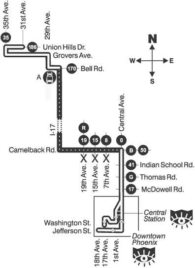
- August 18, 1997 - The earliest known official routing traveled from the old bus terminal at Washington St/Jefferson St & 1st St, up Central Ave, Camelback Rd, Interstate 17, Bell Rd, 29th Ave, Grovers Ave, 35th Ave, and Union Hills Dr to 31st Ave
- March 19, 2000 - By this time, the route had been modified to serve the State Capitol like the other express routes, as well as the new Central Station
- August 14, 2000 - Route modified to serve the new Deer Valley (Bell Rd/I-17) Park and Ride
- January 22, 2007 - Route modified to use Bethany Home Rd instead of Camelback Rd between Central Ave and Interstate 17
- January 24, 2011 - Route eliminated
Page last updated: