
Paradise Valley Express
Express route 500 traveled from 22nd Ave & Lower Buckeye Rd, past the State Capitol and through Downtown Phoenix, then up State Route 51 and 32nd St to Paradise Valley Community College.
Existed: 1993 - 2003
Full Length: 21 miles
Latest Full Route: 22nd Ave & Lower Buckeye Rd to Paradise Valley Community College
Connecting Routes: B R Y 0 3 7 8 10 12 15 19 27 90 106 138 170 186 501 502 510 512 520 521 531 532 533 540 541 560 561 570 580 581 582 590 591 592 DASH
This map is self-made from pieces of data that I was able to find. I tried to be as accurate as possible, but there may be some mistakes!
History
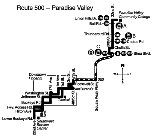
- August 18, 1997 - The earliest known routing of route 500 traveled from 22nd Ave & Lower Buckeye Rd, up 19th Ave, past the State Capitol, through Downtown Phoenix, along Roosevelt St and 7th St to Interstate 10, up State Route 51 to Shea Blvd, serving Shadow Mountain Park and Ride, up 30th St, Cholla St, and 32nd St to Paradise Valley Community College
- March 1, 1998 - Route modified to serve the new Dreamy Draw Park and Ride instead of Shadow Mountain Park and Ride
- March 19, 2001 - By this time, the route had been modified to use Central Ave instead of 1st St in Downtown Phoenix
- July 8, 2002 - Outbound route modified to use 3rd St and Thomas Rd to access State Route 51 instead of Roosevelt St, 7th St, and Interstate 10 due to traffic backups on 7th St
- July 14, 2003 - Route 500 eliminated and replaced by SR 51 RAPID and route 32
Page last updated: